Showing posts with label Camping. Show all posts

Sunday, 2 December 2018

Serenity Sundays - The Mary Valley Scenic Drive And The Seven Steps To Serenity

Sunday Drivers Rejoice!


The details are on the link attached to the photos, but this is the most wonderful way to feel alive and a great reminder of what we have at our fingertips!

Image result for mary valley
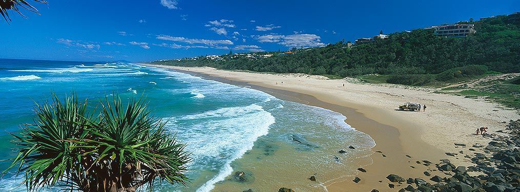
Image Courtesy of the Australian (This would have been gone if the Traveston Dam had not been stopped)


My recipe for happiness on this adventure is:

1. Duck out and fill up the car using one of the petrol finder apps (otherwise there will be less serenity ha) - then "let it go"......

2. Pack up a picnic - folding chairs or a blanket are fine, but a marquis is handy depending on what you find. For the budget-minded make sure you pack a thermos or cold drinks, too. Towels and togs maybe? There are lots of creeks on this drive if you are fearless.

3. Put the starting point in your Bluetooth, or just wing it (more fun)

Related image
Image Courtesy Of Stayz


4. Pack puppy too, if you have one, along with the lead and a water bowl, and treats for being good.

5. Commence drive at the top point (or bottom point if coming from the North), and then work your way back to home, ensuring you stop at every gorgeous spot until one just sucks you in for your picnic.


6. Remember to check out the produce stands when you come across them. Often organic and usually inexpensive - you may even encounter one of the old "honesty" boxes....

7. Wind the windows down and inhale the bush smell!

Sleep like a baby tonight - why? Because these sort of activities always get you thinking about what matters in life and what changes you need to make to become much happier - take the time on this trip to either chat with your other half about what matters, or give yourself the time to really focus.

Saturday, 17 November 2018

Surfari Saturdays! Double Island Point

Surf Spot Double Island Point

This one is off the beaten track (about 2 hours at the top of our region), but if you like 4WD day trips, camping, fishing or surfing, this spot is for you! Probably not for the faint-hearted as it's pretty wild and secluded, but for those who know what they are doing, great spot!

There is a surf school for learners too.

Related image
Image Courtesy of Darren Tierney Galllery where you can purchase online!

Thursday, 15 November 2018

Thirsty Thursday - Secret Watering Holes - Kin Kin Hotel

Kin Kin Hotel

Around half an hour North of Noosa, this little gem is a local best kept secret! It has it all from amazing old fashioned pub food to pool tables, darts and giant outdoor areas. It also boasts a number of traditional pub accommodation rooms for sleep overs and you can even camp in the adjacent oval for large groups.

The publican has no objection if once shut you take a couple of eskies onto the verandah either....just be a bit respectful.

https://www.visitnoosa.com.au/image/noosa-drive/countrylife-04.jpg

This is cool for a weekend away with friends, and has a legendary brekkie spot just over the road.

Pete is the well-ensconced publican and has a lovely nature.

Friday, 9 November 2018

Maroochydore - Did You Know?


 There are a number of possible explanations for Maroochydore. All are based around the black swans which can be seen in the area. Some interpretations explain that the word is an English equivalent of the local Aboriginal word "marutchi" meaning "black swan" or "marutchi dora" meaning "water where the black swan lives". Alternatively the word possibly comes from the Yuggera language, "muru-kutchi" meaning red-bill, the name of the black swan. The Yuggera people lived around Brisbane. The name was given to the area by Andrew Petrie in 1842. Petrie was accompanied by two Yuggera men from whom, presumably, he obtained the name. The name Maroochydore came into general use in 1884.Related image

*Prior to the arrival of Europeans the area along the coast near Maroochydore was home to the Gubi Gubi Aboriginal people. 

* The first European in the area was the Irish convict John Graham who, having been sentenced to seven years transportation for stealing hemp, was sent to Moreton Bay. In July 1826, believing he could row to China, Graham escaped from Moreton Bay. He walked into an Aboriginal camp near the present site of Maroochydore and was immediately accepted as the ghost of one woman's dead husband. Graham lived with the Aborigines for six years.

* In 1833 Graham returned to Moreton Bay and gave himself up.

* Timber-getters were in the area by the early 1850s. They cut timber in the hinterland.

* A depot handling timber was established on the river by 1856.

* The explorer Andrew Petrie passed through the area in 1862 and named the Maroochy River.

* A wharf was built at the mouth of the Maroochy River in 1868.

* In 1888 the Salvation Army held a camp at Cotton Tree.

* William Pettigrew opened a sawmill on the Maroochy River in 1891.

* The Pettigrew sawmill closed in 1898.

* The township of Maroochydore came into existence in 1900.

* In 1907 Thomas O'Connor subdivided land near the river mouth and sold allotments.

 * The Club Hotel was built in 1911.

* A School of Arts and the local Surf Life Saving Club were both operating by 1916.

* A State Primary School was opened in 1921.

* The Maroochy Post Office opened in 1922.

* During the 1920s the Maroochydore Picture Palace and Jazzland was opened.

* A road from the Bruce Highway was opened in 1928.

* The local golf course was opened in 1956.

* It wasn't until the 1960s that the area developed as a major tourist destination.

* The local population doubled between 1961 and 1971.

* The canals at Maroochy Waters were built in the 1970s and 1980s.

Related image
Artists Impression of The New CBD with an interesting article in News.Com
* The Sunshine Plaza was opened in 1995.

NB:Information copied directly from the Aussie Towns site which contains other amazing links for exploration!

Thursday, 8 November 2018

Maleny - Did You Know?


*There are two possible explanations for the naming of Maleny and both of them are spelling mistakes. One theory argues that it was named Maleny because the Balfour brothers, who established the Colinton Station in 1841, were surveyors and they named Malleny Mountain on the Blackall Range after the tiny Scottish town of Malleny. Alternatively it was named after a surveyor named Maloney who worked in the local area. Either way the spelling was pretty bad. It is either Maleny but should be Malleny or Maleny and it should be Maloney ... but never Maleny.

 Image result for maleny

* The area was once occupied by the Nalbo and Dallambara peoples of the Gubbi Gubbi nation who each year gathered at Baroon Pocket on the banks of the Obi Obi River to feast on Bunya nuts. The explorer Ludwig Leichhardt witnessed one of these gatherings and described it as "This plain they call Booroon ... seems the rendezvous for fights between the hostile tribes who come from near and far to enjoy the harvest of the Bunya". In fact it was an annual gathering of Aborigines from as far away as the Gold Coast and the Darling Downs.

* By the 1850s timber cutters had moved into the district and for the next few decades the primary industries were timber cutting and sawmilling. Not surprisingly when it came to naming Maleny's streets the timber industry was acknowledged with streets named Maple, Myrtle and Cedar. By the 1870s the district had a timber mill and a blacksmith.

* On 13 November, 1878 Isaac Burgess selected land on the present site of Maleny. It was the beginning of a period when dairy and beef cattle were grazed on the rich grasses which resulted from the substantial annual rainfall and the rich red volcanic soils.

* A school was opened in 1886 and a local post office in 1890. The town was officially proclaimed in 1891.

* Although dairy farming dominated the local economy (a butter factory was opened in in 1904 and a second factory in 1912) the area became increasingly focussed on mixed farming with small crops and orchards replacing the pasturelands.

* Maleny remained a rural service town until the 1980s when retirees, seeking a cool alternative to the coast, moved in and started building large houses on one and two acre lots. This evolved into the town becoming an arts and crafts centre with a dominant alternative lifestyle. Perhaps the best symbol of this alternative lifestyle was the town's passionate attempt to resist the arrival of a Woolworths supermarket in the early years of the twenty-first century.


NB:Information copied directly from the Aussie Towns site which contains other amazing links for exploration!

Tuesday, 6 November 2018

Yandina - Did You Know?

Image result for Yandina
Image Courtesy Of Sunshine Coast Property Group
*The local Aborigines, the Kabi Kabi, called the district around Yandina 'koongalba' meaning 'small water' and the early settlers named it Native Dog Flat. Eventually the town was named Yandina after the Yandina cattle run which was located east of Mount Ninderry. It is claimed that 'yandina' is a combination of two local Kabi Kabi words 'yan' meaning 'to go' and 'dinna' meaning 'feet' ie to go by foot.


* the district had been settled by the Kabi Kabi people for thousands of years prior to the arrival of Europeans.

* European settlers moved into the area in the 1850s and by 1870 the township of Yandina had been officially surveyed. The predominant industry, as with most of the Sunshine Coast hinterland, was timber with timber cutters logging bunya pine, cedar and beech from the forests.

* a church was built in 1880 and a hotel was opened in 1889. The hotel had to be moved when the railway arrived in 1891.

* Ginger growing had started in the Buderim area shortly after World War I. It was a crop of minor importance until World War II stopped importation from China allowing the industry to expand to meet local demand. The Buderim Ginger Grower’s Co-operative Association Limited, originally located in Buderim, was established by five local farmers. In 1979 it was moved to a much bigger factory in Yandina.

* In 1996 the town was bypassed by the Bruce Highway.


NB:Information copied directly from the Aussie Towns site which contains other amazing links for exploration! Click on the "Underbelly" label for local legend and lore....

Sunday, 4 November 2018

Tin Can Bay - Did You Know?


 *Although there is some dispute as to the meaning of the word it is widely accepted that Tin Can Bay's name is a variant of the local Aboriginal word 'tuncanbar' which may have referred to the dugongs which abound in the area. The word also may have meant a vine or the local mangroves.
Image result for Tin Can Bay
Image Courtesy Of Trip Advisor

 
* In the 1850s a dugong station was established at the mouth of the Kauri Creek, just north of Tin Can Bay, and dugong were killed and their oil extracted in much the same way whales were exploited at the time.

* A European settlement was established around 1870 primarily as a port to ship timber to the Maryborough sawmills. There was also some oyster cultivation.

* Although Norman Point is now a pleasant park and a jetty for the Coast Guard it was originally the site of one of Queensland's first railway lines. The railway was constructed to transport logs to the jetty where they were loaded onto barges and shipped to the mills in Maryborough.

* In 1922 township lots were sold and by the 1930s it had become a popular and cheap holiday destination used mostly by people who lived nearby in the hinterland.

* By 1957 Tin Can Bay had become a fishing village. There was a prawning fleet and by 1971 it had its own fish market.

NB:Information copied directly from the Aussie Towns site which contains other amazing links for exploration! Click on the "Underbelly" label for local legend and lore....

Friday, 2 November 2018

Coolum - Did You Know? By Astute Alexandra Headland

 Astute Alexandra Headland


Coolum - Did You Know?


The name is derived from the local Undumbi word gulum or guloom, meaning "blunt" or "headless", referring to the shape of Mount Coolum, which has no peak. [2] According to Aboriginal legend, Ninderry knocked off Coolum's head and it fell into the ocean and is now Mudjimba Island.
The Coolum district was the traditional land of the Inabara or Yinneburra clan of the Undanbi Tribe. In turn, they were part of the larger group of the Kabi Kabi. 

In 1823, the first Europeans to pass through Coolum were castaways and shipwrecked sailors. The first land selection in Coolum was made in 1871 by Grainger Ward - a pastoral lease of 255 hectares. Here, Ward ran upwards of 300 head of cattle. In 1881, Mark Blasdall selected his own lease of 252 hectares. Blasdall was the first to plan sugarcane in the area and to cut timber. He built two huts and a sawmill as well as clearing Coolum Creek, thus enabling steampships to enter to load timber and deliver supplies. By 1882 the steampships 'Tadorna Radjah' and 'Gneering' began to regularly travel from Brisbane to Coolum creek. In 1883 the first Coolum land was freehold and by 1884, Blasdall was declared insolvent and his land freeholded.

Image result for Coolum
Image Courtesy Of Coolum Beach Real Estate


The first permanent settler of Coolum was William Perry-Keene and his family in 1905. His home was called "Green Hills" and was situated at the corner of Beach Road, Daytona and Key West Avenues. Between 1906 and 1912 many people settled permanently in the region. By 1912 there were eight to 12 families living in the district. In 1909, Coulsin established a mailboat service on the Maroochy River. This provided the first regular connection between Coolum and the railhead at Yandina. In 1911, a horse-drawn tramline and punt loading facilities were built at Coolum Creek. 


Construction of the first paved road to Coolum was undertaken between 1922 and 1925. This provided vehicle access from Coolum to Yandina. In 1923, the tramline to Coolum was opened and unscheduled passenger services began. Over this time considerable expansion of the sugarcane industry took place. Cane farming provided the main source of financial stability in the district until the advent of tourism in the 1960s.

The Coolum Library opened in 1989 with a major refurbishment in 1997.[3]
 
In 2002 Coolum hosted the Commonwealth Heads of Government Meeting, replacing the 2001 meeting that was postponed and moved from Brisbane in the wake of the September 11 attacks

In 2006 Australian census, the population of Coolum was 7,744.

Friday, 26 October 2018

Mapleton - Did You Know?

Image result for mapleton images
Image courtesy of Trip Advisor


Early settlers of the area grew fruit, vegetables and ceral crops. The first timber cutters extracted red cedar and beech timber taking it to Nambour. Initially the settlement was known as Luton Vale until 1899 when the name was changed after the English town.
In 1906 the road from the Mary Valley to Mapleton was complete. By 1909 a sawmill was operating in the town.  It closed in 1972. From 1915 through until 1944, Mapleton was served by a 2 ft (610 mm) gauge tramway which ran nearly 18 kilometres from Nambour. It was worked by two shay locomotives

Pineapples, dairying and small crops were the towns major industries until the late 1950s. The scenic beauty of the area has allowed tourism to dominate in the decades since.
Mapleton, a rural town, is at the northern end of the Blackall Range, 95 km north of central Brisbane and 25 km inland from Maroochydore. In 1892 a postal receiving office was opened at a local farm house when the area was known as Luton. Two years later it was decided to name the postal site Mapleton, possibly after a village in Derbyshire, England.

Farm selections for orchards and plantations were taken up in the 1890s, but the unique quality of Mapleton was its elevation, offering relief from the muggy conditions of the Maroochy coast. By the early 1900s Mapleton had the Ocean View hotel and several guesthouses. It was described as the gateway to the Blue Mountains of Queensland. In 1915 a tramway from Mapleton via Kureelpa to Nambour was opened to carry produce to the North Coast railway line, answering a long felt need by the Mapleton Fruit Growers and Farmers Association. 

Image result for mapleton
Image Courtesy of Expedia


With a population of about 250, Mapleton was described as a dairying and fruit-growing district in Pugh's Queensland directory in 1925, with a few stores, tradespeople and two sawmills. It continued in much the same rural environment for the next 60 years until Sunshine Coast tourism and the tourist route through Montville and the Blackall Ranges brought it to prominence. Its population doubled between 1986 and 1996, with the addition of numerous attractions and an annual writers' festival.

Mapleton Falls National Park is two km west of the township, and the Lilyponds in the town centre are a popular picnic spot. Mapleton also has a primary school (1899), a church, a local hall and library, a bowling club, a hotel and a caravan park. To the north of the town in Post Office Road is St Isidore's homestead, an elaborate house built in the early 1900s for a pioneer citrus orchardist. It is listed on the Queensland heritage register. 

Information sourced directly from Wikepedia and the Queensland Places site, run by the University of Queensland.

Monday, 22 October 2018

Mudjimba - Did You Know?

Mudjimba, a coastal urban area between Coolum Beach and Maroochydore is 100 km north of central Brisbane. It was named after Mudjimba Island, a well vegetated rocky islet about two km due east of Mudjimba.

The island is the subject of at least two Aboriginal legends. One involved two women making a home on the island, where there were midyim berry bushes. When only one of the women could be seen on the island, it became known as Old Woman Island. The same legend concerned the midyim berry bush - hence 'midyam' becoming altered to 'Mudjimba'. A second legend interpreted the island as being the head knocked off the top of a warrior, Coolum, which is represented as the flat-topped Mount Coolum about six km northwards.

Mudjimba was part of the coastal strip development northwards to Noosaville following the construction of the David Low Way coastal road in the early 1960s. It has an unbroken beach southwards to the mouth of the Maroochy River along with a surf life-saving club, a caravan park and a foreshore reserve. Twin Waters golf course separates the township from the neighbouring suburb of Pacific Paradise. Twin Waters was financed by the failed financial institution Tricontinental, and remained in its portfolio until sold to Lend Lease in 2003.

Mudjimba Beach on the Sunshine Coast of Qld. Lady Island lies about 1 Kl. off shore. I have walked this beach with my sister a few times since I have moved to Qld. It really is a beautiful beach.


In 2005 the suburb of Twin Waters was created, reducing Mudjimba's area by about half, leaving it with the part of Maroochy River Conservation Park north of Ocean Drive. The Mudjimba caravan park is inset in the north-east corner of the conservation park.

The failure of the Twin Waters/Tricontinental venture, however, appeared to be beneficent, as median house prices grew by 85% in Mudjimba during 1996-2001. Pacific Paradise's prices grew by just 18%. The Sunshine Coast airport is immediately north in Marcoola. 

Information sourced directly from the Queensland University website, Queensland Places

Wednesday, 17 October 2018

Peregian Beach - Did You Know?

Peregian Beach is a slender beachside township on the Sunshine Coast, 110 km north of central Brisbane and 10 km south of Noosa Heads. 

Peregian is an Aboriginal word for emu.

During World War II, Peregian Beach, Sunshine Beach and surrounding areas were used for artillery training. Current residents occasionally discover artillery shells and unexploded ordnance on their land. On making such discoveries, residents should call the Police who will arrange for inspection and, if required, safe disposal.

In the 2011 census, Peregian Beach had a population of 3,531 people.

In 2015, there was a competition for local residents to choose one of four pieces of artwork to decorate the concrete walls of the Peregian Beach Reservoir.[ The winning artwork was "Peregian Stand" by Peregian artist Colin Passmore which depicted a stand of melaleuca trees.

Image result for Peregian beach
Image courtesy of Wotif.
 

A short distance inland from Peregian Beach there are dunes and sandy swamp land. Originally a haven for coastal flora and wildlife, the area was little fitted for grazing or agriculture and was accessed by a few sandy tracks. In the late 1950s the State Government entered into a public / private sectors arrangement for tourist development of the Sunshine Coast, involving the building of a coastal road and generous provisions for coastal land subdivision. Alfred Grant Pty Ltd promoted the Peregian Beach development, which was taken over by T.M. Burke after the 1961 credit squeeze 
(Burke had also planned and promoted Sunshine Beach and Marcus Beach, immediately to the north).

Peregian Beach is both a resort and a retirement town. The Noosa/Lake Weyba National Park is immediately inland, and there is a foreshore reserve along the town's entire length. 

There are a shopping centre, a hotel and a caravan park near its midpoint. The Peregian Beach Community College (2002) is just beyond Peregian Beach's border with Weyba Downs. 

Information courtesy of Queensland Places and Wikepedia.

Sunday, 14 October 2018

Noosa and Noosaville - Did You Know?

Noosa Heads and the adjacent Noosaville are 120 km north of central Brisbane, on the south shore of Laguna Bay and the mouth of the Noosa River. Since the 1960s Noosa has boasted some of Australia's most expensive coastal real estate. Like Byron Bay in northern New South Wales it draws tourists all year round from the southern states and overseas, especially Europe.

The Noosa sand mass is similar to the great dune formations that constitute the Cooloola sand mass and off-shore islands including Moreton, Stradbroke and Fraser. Noosa is underlain by rock, which caused the retarding and settlement of coastal sand drift. The Noosa sand mass is partially separated from the mainland by Tin Can Bay, Noosa River and Lake Cootharaba. It is thought that the name was derived from an Aboriginal word describing shade, shadow or ghost. The Kabi tribe inhabited the region between Redcliffe in the south, the Noosa River mouth and Cooroy and Nambour to the south-west.

Image result for images of noosa little cove
Image Courtesy of Stay In Noosa
A Brisbane timber merchant, William Pettigrew, had explored the Maroochy district for timber harvesting, and in 1863 he inspected the Noosa River and its lakes. The first European settlement in the area was Elanda Point on Lake Cootharaba, from where logs were taken downstream to a wharf at Tewantin on the 'Nusa Harbour'. In 1870 a selector, Walter Hay, took up land on which the Tewantin township was surveyed (1870) and his land holdings included Hays Island (now Noosa Sound) and parts of Noosaville. Noosa village, consisting of allotments along both sides of Hastings Street, was surveyed in 1879, and most allotments were sold by 1885. Laguna House on Hastings Street was built in the late 1890s. A short walk north from Hastings Street brought visitors to the ocean beach. By about 1900 holiday makers from Brisbane and Gympie made their way beyond Tewantin, finding accommodation in Laguna House or Bayview (Hillcrest Guest House) in Noosa Drive. Neighbouring Noosaville was known as Gympie Terrace.


Fishing and swimming were excellent at Noosaville and Noosa Heads, and access was by boat from Tewantin, reached by car from the Cooroy railway station. The first Life Saving Club was established at Noosa in a tent in 1927. In 1929 a real estate developer, T.M. Burke, built bridges across Doonella Lake and Weyba Creek: holidaying motorists queued up to cross them. In return for building the bridges, T.M. Burke received 470 acres of land from the shire, but land sales languished.

In 1959 the T.M. Burke firm joined with the State Government in building the David Low coastal road which opened up Noosa Heads for visitors and tourists. (Burke's also developed the adjoining coastal suburbs of Sunshine Beach and Peregian Beach, again on land acquired in return for road building.)
Intermittent cyclonic conditions have changed the size of the beach, and beach erosion in 1967 prompted the placement of rock fill to protect beachfront properties. Wave turbulence coming back off the rocks further eroded the beach and natural sand replacement did not cover the rocks. Sand pumping was needed. Developers then looked inland, and in the 1970s Burke's proposed to re-engineer Hays Island as a canal estate. Residents of Tewantin and Noosa Heads were sensitive to loss of vegetation, erosion of the landscape and the prospect of high-rise buildings as they did not want Noosa to become another Gold Coast. The Noosa Parks Association (1962) succeeded after 30 years of agitation in having several parks and reserves permanently kept aside. Noosa Spit, the southern 'Noosa Head', missed being developed after a bitter debate. A second canal estate, west of Hays Island and in Noosaville, was proposed by Burke's in 1973. It had to be modified to a non-navigable lake system with an outlet weir, and was completed in the late 1980s.

Image result for Noosaville
Image Courtesy Of Visit Noosa


Hastings Street's urban design testifies to stubborn local resistance to over-ambitious developers. Purists may quibble, but in terms of resorts there is some truth in the tourist blurbs that Noosa 'combines a village and cosmopolitan atmosphere ... managing to maintain natural beauty, while growing as a tourist centre'. Restaurants of international standard and luxury apartments are within walking distance of both Noosa Spit and the 477 ha Noosa / Lake Weyba National Park (created 1930, expanded 1949). Lugana Lookout on the edge of the park offers an unexcelled view over Noosa inlet. Laguna House in Hastings Street was replaced by units and shops and finally by Sebel apartments (1999). Dining and self-contained, low-rise apartments expanded into Gympie Terrace, the esplanade beside the river in Noosaville.

Noosa Heads is tourist oriented and Noosaville houses much of the local workforce in conventional residential estates. However, it also includes the luxury Noosa Sound (1973) and Noosa Waters (1991) on the former Hays Island. Both have residential and resort accommodation. Noosaville has the Noosa private hospital (1999), the Good Shepherd Lutheran College (1986) and St Teresa's Catholic College (2004). The State primary school on Noosaville's western boundary was opened in 1996, sharing its catchment with Tewantin. Luxury shopping is in Hastings Street, and the Noosa Fair drive-in shopping is at Noosa Junction (1987), criticised at the time of its opening as a prime example of inappropriate design. In 2006 Noosa Civic Shopping Centre, three times as big as Noosa Fair, was opened in the south of Noosaville, adjoining an industrial area.

Information directly from Queensland Towns.

Thursday, 11 October 2018

Tewantin - Did You Know?

Tewantin, a town, is 120 km north of central Brisbane and about 4 km inland from Noosa Heads. It is thought that the name was derived from an Aboriginal word describing dead trees or logs, possibly a reference to timber brought down the Noosa River to a wharf at Tewantin in the 1860s, just west of the present bridge over Doonella Lake.

Image result for tewantin
Image courtesy of Visit Noosa


Tewantin was first settled by Europeans permanently in 1870 and in 1871 a township surveyed. Early industry revolved around timber getting and milling, the steamer Culgoa plying the coast to Brisbane delivering timber, fish and oysters. Tewantin township was surveyed in the vicinity of the timber wharf, which was approached by a midden of oyster shells across the beach. There were also a hotel and a post office, and some buildings were built from logs washed up from a cargo of timber that had been abandoned. Tewantin was a busy port, not only for timber transport but for passengers who preferred steamer voyage and coach connection to Gympie over the inland track from Brisbane to the goldfields town. Fish and oysters were also dispatched to Brisbane. The opening of the railway from Brisbane to Gympie in 1889 reduced boat passenger numbers, but by then Tewantin's Royal Mail Hotel had become established as a holiday destination for Gympie's inhabitants. The establishment of a viable alternative transport route other than sea was perhaps fortuitous, for in 1891 the Culgoa came to grief on the Noosa Bar.

Tewantin, however, was in need of economic diversification as timber resources were depleted and the mills and wharves fell into disuse.
A degree of salvation came through tourism. Before the development of Noosa Heads, Tewantin was the "Honeymooners' Paradise" and the centre of a 'Lakes District', a reference to Lakes Cootharata, Cooroibah and Como along the Noosa River, and Lakes Doonella and Weyba off Noosa Inlet. They provided a nature's wonderland. Penrod's Guide (1957) indicated that Tewantin (with a population then of about 1800 people) offered rowboats and motor dinghies for hire and fishing, golf links, bowls, tennis, picture theatre, dance hall, shops, garages and cafes. Accommodation was available at the hotel, guesthouses, flats, houses to let and the caravan park. Visitors to Tewantin could cross to Noosaville on the Doonella Bridge (1929).

Within ten years of Penrod's account the tourist focus had shifted from Tewantin to Noosa Heads, particularly with the opening of the coast road. Developers seeking to emulate the successful Gold Coast canal estate developments were attracted to the Noosa area in the 1970s, spotting the potential presented by Hays Island (Noosa Sound). Tewantin's subsequent growth tended to be as a dormitory suburb to the tourism industry at Noosa: by 2001 only 5% of Tewantin's census count was non-resident, whereas 30% of Noosa's was non-resident, ie holiday makers.


Tewantin has three churches, three aged persons' residential facilities, a golf course, a State primary school (1875), TAFE (2004), sports complex and the offices of the former Noosa Council, relocated from Pomona in 1980 to the site of the former Tewantin caravan park. There are state forests to its west and south.


Info directly from Queensland Places

Tuesday, 9 October 2018

Sunshine Beach - Did You Know?

 The area south of Noosa Headlands was formerly known as Golden Beach but was rarely visited before the 1920s. In 1928, Thomas Marcus Burke gained land there in exchange for building roads and bridges from Tewantin. After World War II it was marketed by his son, Marcus, as Sunshine Beach.

Sunshine Beach and neighbouring Marcus Beach are on the Sunshine Coast, 115 km north of Brisbane and immediately south of Noosa Heads. Both are the product of successful real-estate developers, Alfred Grant Pty Ltd and TM Burke Pty Ltd, in the 1950s-60s.
Sunshine Beach is reached by David Low Way, a coastal road jointly financed by the State Government and the developers, the latter gaining generous subdivision approvals from the government and Noosa Shire.
Image result for sunshine beach
Image courtesy of Visit Noosa


Despite the suburb's proximity to the Noosa/Lake Weyba National Park, Sunshine Beach has been criticised for the lack of neighbourhood recreation space. It provides most of the educational facilities for Noosa - Sunshine Beach, State (1982) and Catholic (1990) primary schools and a high school (1992). There are also two churches, a campus of the University of the Sunshine Coast, a drive-in shopping centre and surf life-saving club.

Information courtesy of Wikepedia and Queensland Places

Tuesday, 2 October 2018

Rainbow Beach - Did You Know?

* The earliest inhabitants, the local Aborigines, were camping on Inskip Point, which they called Carah, up to 10,000 years ago.

* On 18 May, 1770 Captain Cook sailed past and named both Carlo Sand Blow and Double Island Point.

* The first Europeans to settle in the area in the early 1900s when timber cutters. There numbers were sufficient for a school to be established for their children. The need to ship the timber to Maryborough resulted in a lighthouse being built at Double Island Point and lighthouse keeper being employed to keep watch over the entrance to the Great Sandy Straits.

*  Zircon, ilmenite and rutile were mined on Inskip Point between 1965 and 1971 by Queensland Titanium Mines. They developed simple accommodation and access roads to the area.

* In 1967 a tourist ferry service was started between Tin Can Bay and the southern reaches of Fraser Island.

* Development of the area is so recent that Tin Can Bay wasn't officially gazetted until 1969 and that was only because of the local sand mining industry. It was around that time that the government built a road to Rainbow Beach.

* Sand mining in the area was relatively short-lived. It ceased in 1976.

Info copied directly from the Aussie Towns website


Sunshine Coast - Was 80s Mecca for Nightlife and Live Bands!

 There are no words for how good we had it!  Let's start with this video/pictures courtesy of the Sunshine Coast Daily/Courier Mail and ...