Showing posts with label Noosa. Show all posts

Thursday, 24 March 2022

Sunshine Coast - Was 80s Mecca for Nightlife and Live Bands!

 There are no words for how good we had it! 

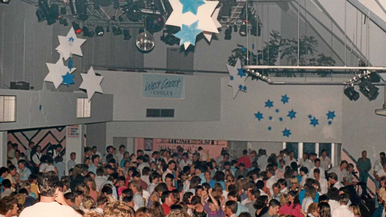
Let's start with this video/pictures courtesy of the Sunshine Coast Daily/Courier Mail and then start listing the live bands we saw here on the Coast weekly! Sadly developers have trashed this part of our history but they can't trash our treasured memories....

Click here to view The Galaxy (Chiffley's) at its peak!


It seemed the fun never stopped | The Courier Mail


This is a game we play with our friends....start listing all the cool bands you have seen on the coast in the 80s and 90s....I'll get you started with a few, and a lot of these are still going! You add yours in the comments! We always get to over 100!


  1. The Cult
  2. The Divinyls
  3. Hoodoo Gurus
  4. Painters and Dockers
  5. TISM
  6. Sunny Boys

Wednesday, 28 November 2018

Wednesday Walkies - Noosa National Park

Wednesday Walkies - Noosa National Park


It would be remiss of me to not include this famous walk featured on our beautiful Sunshine Coast.

Most of the locals are fully aware of it, but if we don't actually live at Noosa, we can forget it exists! Unless you surf of course ha!

I have attached a really good link (click on the picture).

Now as long as you don't mind seeing a few "nudie-rudies" on your way (along with a few sad little peeping toms), and as long as you don't mind seeing Koalas, Dolphins and bronzed gods on their boards, you can probably cope with this stunning walk!


Noosa National Park
Image Courtesy Of Sunshinecoast.com

Sunday, 14 October 2018

Noosa and Noosaville - Did You Know?

Noosa Heads and the adjacent Noosaville are 120 km north of central Brisbane, on the south shore of Laguna Bay and the mouth of the Noosa River. Since the 1960s Noosa has boasted some of Australia's most expensive coastal real estate. Like Byron Bay in northern New South Wales it draws tourists all year round from the southern states and overseas, especially Europe.

The Noosa sand mass is similar to the great dune formations that constitute the Cooloola sand mass and off-shore islands including Moreton, Stradbroke and Fraser. Noosa is underlain by rock, which caused the retarding and settlement of coastal sand drift. The Noosa sand mass is partially separated from the mainland by Tin Can Bay, Noosa River and Lake Cootharaba. It is thought that the name was derived from an Aboriginal word describing shade, shadow or ghost. The Kabi tribe inhabited the region between Redcliffe in the south, the Noosa River mouth and Cooroy and Nambour to the south-west.

Image result for images of noosa little cove
Image Courtesy of Stay In Noosa
A Brisbane timber merchant, William Pettigrew, had explored the Maroochy district for timber harvesting, and in 1863 he inspected the Noosa River and its lakes. The first European settlement in the area was Elanda Point on Lake Cootharaba, from where logs were taken downstream to a wharf at Tewantin on the 'Nusa Harbour'. In 1870 a selector, Walter Hay, took up land on which the Tewantin township was surveyed (1870) and his land holdings included Hays Island (now Noosa Sound) and parts of Noosaville. Noosa village, consisting of allotments along both sides of Hastings Street, was surveyed in 1879, and most allotments were sold by 1885. Laguna House on Hastings Street was built in the late 1890s. A short walk north from Hastings Street brought visitors to the ocean beach. By about 1900 holiday makers from Brisbane and Gympie made their way beyond Tewantin, finding accommodation in Laguna House or Bayview (Hillcrest Guest House) in Noosa Drive. Neighbouring Noosaville was known as Gympie Terrace.


Fishing and swimming were excellent at Noosaville and Noosa Heads, and access was by boat from Tewantin, reached by car from the Cooroy railway station. The first Life Saving Club was established at Noosa in a tent in 1927. In 1929 a real estate developer, T.M. Burke, built bridges across Doonella Lake and Weyba Creek: holidaying motorists queued up to cross them. In return for building the bridges, T.M. Burke received 470 acres of land from the shire, but land sales languished.

In 1959 the T.M. Burke firm joined with the State Government in building the David Low coastal road which opened up Noosa Heads for visitors and tourists. (Burke's also developed the adjoining coastal suburbs of Sunshine Beach and Peregian Beach, again on land acquired in return for road building.)
Intermittent cyclonic conditions have changed the size of the beach, and beach erosion in 1967 prompted the placement of rock fill to protect beachfront properties. Wave turbulence coming back off the rocks further eroded the beach and natural sand replacement did not cover the rocks. Sand pumping was needed. Developers then looked inland, and in the 1970s Burke's proposed to re-engineer Hays Island as a canal estate. Residents of Tewantin and Noosa Heads were sensitive to loss of vegetation, erosion of the landscape and the prospect of high-rise buildings as they did not want Noosa to become another Gold Coast. The Noosa Parks Association (1962) succeeded after 30 years of agitation in having several parks and reserves permanently kept aside. Noosa Spit, the southern 'Noosa Head', missed being developed after a bitter debate. A second canal estate, west of Hays Island and in Noosaville, was proposed by Burke's in 1973. It had to be modified to a non-navigable lake system with an outlet weir, and was completed in the late 1980s.

Image result for Noosaville
Image Courtesy Of Visit Noosa


Hastings Street's urban design testifies to stubborn local resistance to over-ambitious developers. Purists may quibble, but in terms of resorts there is some truth in the tourist blurbs that Noosa 'combines a village and cosmopolitan atmosphere ... managing to maintain natural beauty, while growing as a tourist centre'. Restaurants of international standard and luxury apartments are within walking distance of both Noosa Spit and the 477 ha Noosa / Lake Weyba National Park (created 1930, expanded 1949). Lugana Lookout on the edge of the park offers an unexcelled view over Noosa inlet. Laguna House in Hastings Street was replaced by units and shops and finally by Sebel apartments (1999). Dining and self-contained, low-rise apartments expanded into Gympie Terrace, the esplanade beside the river in Noosaville.

Noosa Heads is tourist oriented and Noosaville houses much of the local workforce in conventional residential estates. However, it also includes the luxury Noosa Sound (1973) and Noosa Waters (1991) on the former Hays Island. Both have residential and resort accommodation. Noosaville has the Noosa private hospital (1999), the Good Shepherd Lutheran College (1986) and St Teresa's Catholic College (2004). The State primary school on Noosaville's western boundary was opened in 1996, sharing its catchment with Tewantin. Luxury shopping is in Hastings Street, and the Noosa Fair drive-in shopping is at Noosa Junction (1987), criticised at the time of its opening as a prime example of inappropriate design. In 2006 Noosa Civic Shopping Centre, three times as big as Noosa Fair, was opened in the south of Noosaville, adjoining an industrial area.

Information directly from Queensland Towns.

Sunshine Coast - Was 80s Mecca for Nightlife and Live Bands!

 There are no words for how good we had it!  Let's start with this video/pictures courtesy of the Sunshine Coast Daily/Courier Mail and ...